
If you prefer an alternative format you can listen to Alison reading episode 4 on Soundcloud.
***
The long, dry spell has ended and Glasgow is living up to its rainy reputation. I’ve watched the clouds gathering: out my window, while outside—as I have been much of the last few weeks—and from above, as I re-view the images and documentation I have collected. They represent many full weather-ed moments—rainbows appearing in the path of a satellite, shielding my laptop from the rain, holding the antenna wavering against the wind—as well as the social encounters and listening experiences that have been drawn out by this practice of paying close attention to the weather.
As restrictions have eased I travel to Edinburgh, to return to Calton Hill and the site of the City Observatory. I’ve been thinking about closed loops: the closure in being able to make a return to Calton Hill, and closing this series of writing, if not—perhaps—concluding my experiments with radio and satellites.

[Setting up the DIY ground-station on Calton Hill on 20 April 2021]
*
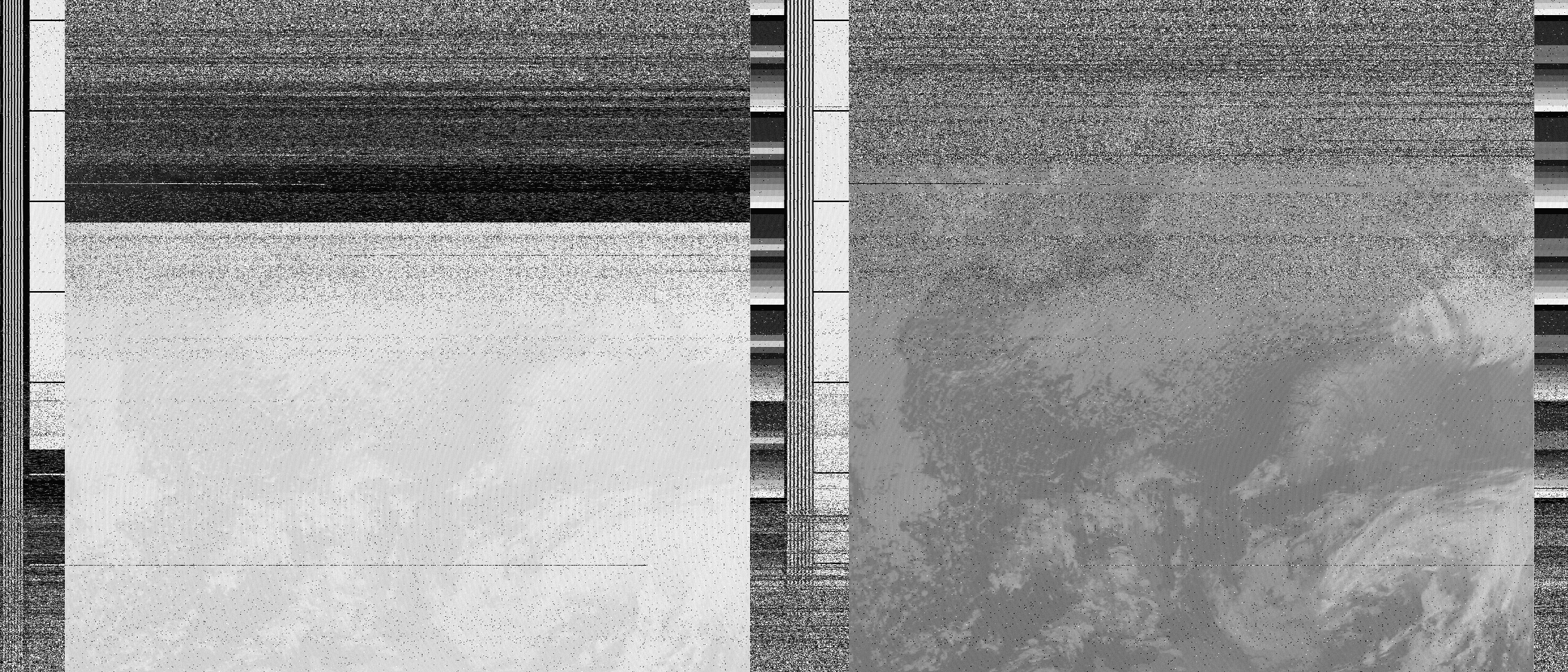
I set up my portable DIY ground-station at the trig point, away from the many buildings and monuments—obstacles to the satellites signal—with an open view of the Firth of Forth. I catch four passes in fairly quick succession, moving between their slightly different frequencies: NOAA 15 (137.62MHz), NOAA 18 (twice, on 137.92MHz), and NOAA 19 (137.10MHz). I raise my antenna to the open sky, engaging from the ground again and again in the ‘vertical field’—what Lisa Parks describes as the ‘combination of terrestrial, aerial, spectral, and/or orbital domains’.[1] The turnstile antenna’s cross axis is visually something like the compass rose on the Nelson Monument, a towering monument to militaristic hierarchy, empire, war: verticality. Rotating with the compass—panning slowly with the satellite passes that come either from the north or south—I hear the satellite’s tick-tock disappear behind Collective’s domed Observatory site. It’s a bright, still day, uncannily and peacefully empty. The decoded images, as a series, follow small changes in the cloud patterns as they develop over the day: the same weather and landscapes at slightly different times, slightly different angles. They are streaked with static, the thinking fuzz. One of the images I decode, from NOAA 19, has a large silvery sun-glint over the Baltic sea. Sunlight reflects off the smooth water at the same angle as the satellite is viewing the surface.
Spending so much time looking up, squinting to the sun and wind, I’ve been wanting to try decoding a weather satellite image at night. To look at the dark sky, and think more closely about the aesthetic regimes at play in open-weather, this crossover between meteorology and astronomy I’ve been encountering. To perhaps see the satellite move across the sky while hearing its call, and consider its forms of visualisation, by looking more closely at the satellite images I’ve been decoding.
*
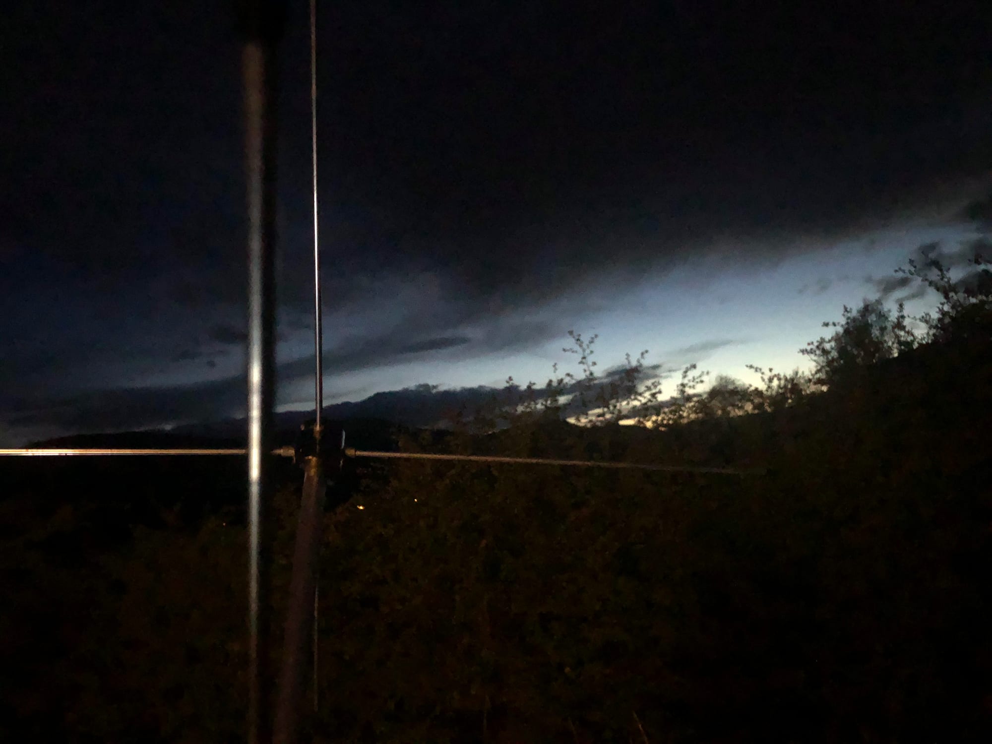
And so, back in Glasgow, one evening I meet artist Becky Šik in a wide empty field lined with trees as the undersides of the full bodied clouds above turn peach-orange-brown in the gloam. There’s a full moon but we can’t see it, the laptop screen glows bright and sparks of light come from distant flats as the dusk turns to darkness. I’ve been having trouble with one of my cable connectors: feeling around with the antenna, listening for the signal in the dark, I start to think we won’t hear NOAA 18. When I squeeze the dodgy cable tight with my fingers the satellite’s beeps burst through the crackle.
Recently spending lots of time recording bat calls, Becky is fairly used to hanging out at night in dark places, listening in to high pitched, passing, secretive and distant creatures, and so she is an ideal and excited companion. We discuss how instruments allow us to amplify the sounds to a register we can hear, recalling last week’s thinking on séance, and sharing our experiences of doing these activities of amature eavesdropping in public spaces. Feeling out of place in familiar places, feeling like a target, while also enjoying the activity of listening. Becky spots the satellite’s pips of light in a break in the clouds. My sense of scale is shot in my disbelief that it, that, is NOAA 18 crossing above us at an altitude of 854km, up in the ionosphere. It seems too much to the west, too far, too high, but I concede that probably is it, moving across the sky. Nevertheless it is a satellite: the sky is dark but full. I add I see you to my usual inhale of recognition, I hear you, upon locking onto the satellite’s call. We follow it for a bit before it disappears beyond the treeline.
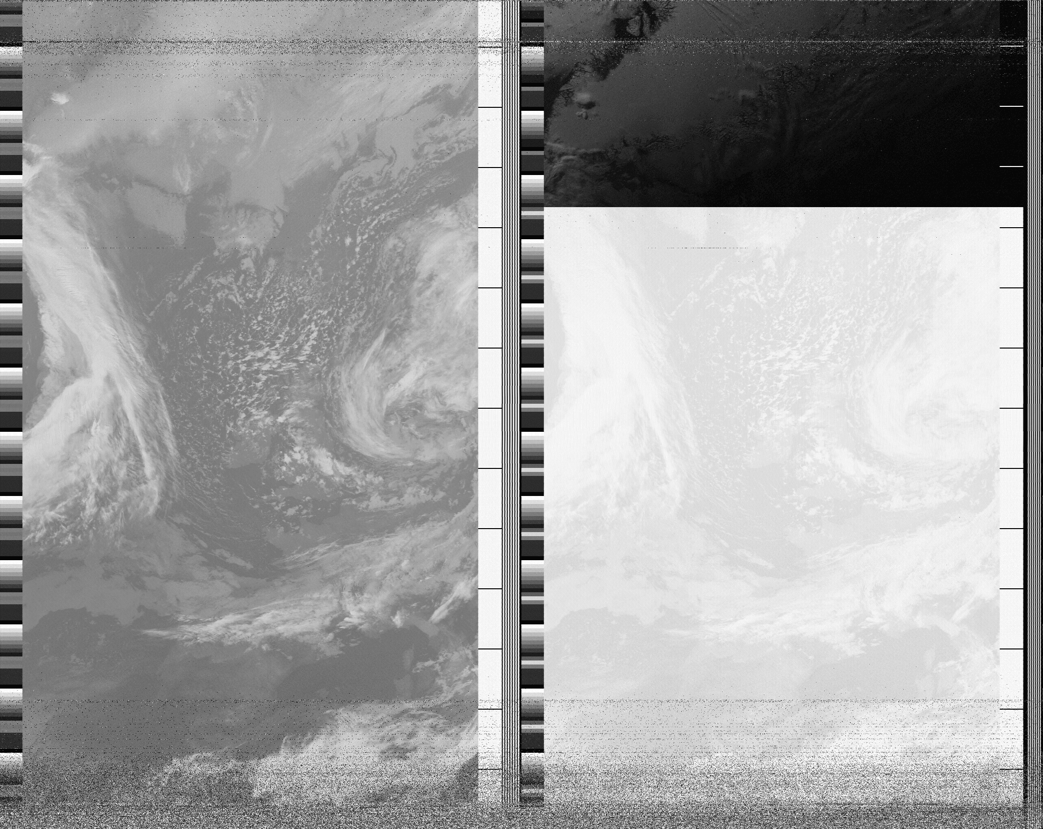
[Infrared image on the right. NOAA 18 captured by Becky Šik and Alison Scott on 29 April 2021 at 21:30 in Glasgow, Scotland]
*
The NOAA 18 broadcast Becky and I decode together at night is interesting to me as, of the two side-by-side images, the infrared image is the most clear—unlike during the day and in the rest of my images. Visible light data is obviously lacking in the dark—there being little to no sunlight or artificial light bouncing off the ground—leaving the other image bleached out and indistinct, after it turns to black. The image produced by infrared light data uses part of the unseen electromagnetic spectrum, with longer wavelengths than visible light: radiant energy that we normally detect as heat.
Looking at the decoded infrared images I am gathering, over this period of time, I think about what these images are generally used for: who reads them and why? Tracking NOAA 18 and focusing on infrared, I realise I am most familiar with infrared imaging used as ‘night vision’ for camera traps on wildlife shows: seeing creatures of the night, with bright glowing eyes looking back, unaware of their surveillance. When I worked in a cinema I was told we could use their (very bad quality) infrared goggles to check in on the audience—especially the back seats—without disrupting the screening. Something I don’t think I did after the novelty of being shown them. In the NOAA images, I begin to notice how the infrared images reveal whole swathes of weather not picked up by visible light. At the level of the state, infrared technology—including high resolution vertical mapping—is used by states to track and target heat-bearing objects: energy plants, communication transmitters, moving vehicles, weapons, human bodies.
[Alison Scott capturing NOAA 18 at 23:28 on 4 May 2021 in Cove, Scotland]
*
When re-viewing the visible light satellite images I have decoded, downlinked from the ionosphere, it is hard to remember that these are not photographs, but rather geo-spatial images generated by processing data gathered from satellites—orbiting bodies equipped with sensory instruments to detect visible light (and other frequencies of electromagnetic radiation) emanating or reflecting off objects and surfaces.
The radio transmission from NOAA satellites embeds what seems like an analogue aesthetic—the lines of static, the relatively low resolution images. But with earth-imaging, as TJ Demos writes, ‘we have moved essentially beyond photography (historically and conventionally gauged to human perception) to remote sensing technology (scaled to global, even inter-planetary measurements).’[2] It is clear that satellite images have their own aesthetic regimes and cultural histories (linked but different to that of photography) that are themselves formed by state and corporate tendencies to use satellites as technologies of surveillance and capitalising extractions. Outwith these hands, for Lisa Parks:
‘... in the context of geospatial images, the struggle over interpretation—including the refusal to read satellite images like a state—becomes a vital dimension of challenging strategies of vertical domination.’[3]
Making and reading—and now to an extent interpreting to you—images from NOAA satellites, it has become evident to me how much of an oppositional tactic open-weather’s assertion that the body, the situational, and process can be, as such, a refusal of vertical domination. As ‘the perspective from above establish[es] an imaginary floating observer and an imaginary stable ground’[4] open-weather’s challenge to the ‘view from nowhere’ reconnects with the materiality of unseen infrastructure and asserts locality and subjectivity in a view from somewhere. The omnipotent eye of a government-commercial satellite is brought close to my body as I track it through an antenna held at arm's length.
In ‘Weather as Medium’, Janine Randerson describes art practices such as open-weather as, if not hacking, ‘hitch-hik[ing] on existing meteorological streams… artists bring the body and social exchange back into mapping processes.’[5] Co-opting satellite transmissions for social exchange and collective acts of learning have been key to me in understanding the open-weather project and approaching the technologies and fields it crosses into: taking part in a workshop with open-weather—Sasha and Sophie—and introducing the activity to others, Becky, Rosie, and Kirsty. In her essay ‘Orbital Performers and Satellite Translators’, Parks positions two branches of art-satellite interactions, both of which emphasise a different agenda to that of the state in their ‘hitch-hiking’, and for me speak to the embodied, counter-geographical experience of taking part in open-weather:
‘The orbital performer uses the satellite as a technology of intimacy rather than one of imperialism’, while, ‘the satellite translator appropriates processes of signal processing and distribution not only to generate art works but also to reveal institutional control of satellites, expose ideological currents that are produced and circulated via satellite and extend technological literacy.’[6]
[Infrared image on the left. NOAA 18 captured from Cove, Scotland, by Alison Scott at 23:28 on 4 May 2021]
*
I realise I have been writing about listening to NOAA satellites as though they are creatures, in relation to the creature that is my DIY ground station—my body augmentated by my antenna, some cables and a laptop. That is, the sensing creature I become while taking part in open-weather. I am taken by Gayatri Spivak’s term ‘planetarity’—planetary-alterity—that positions the planet itself as a species of alterity and difference. Jennifer Gabrys describes the potential of this gesture to a human sense of scale, following Spivak:
‘The planetary is the difference, distance, and duration with, within, and against which it might be possible to think differently about being human and becoming collective.’[7]
Embedding difference at the heart of a planetary imaginary, Spivak’s capacious notion of planetarity motions toward other collective inhabitations of the Earth. For both these thinkers, the planet Earth is not a closed blue marble, a discrete sphere, but a dynamic and shifting creature of many composite beings—whose very edges are in flux. As creatures we participate in the world in particular ways, as sensational, webbed entities.
This notion allows for a reconfiguring of the hierarchies of the ‘vertical field’ that dominates as a world-view: revealing the ‘constructedness of vertical forms of power and challeng[ing] their stronghold on political imaginaries and everyday social relations’.[8]
This shifts the horizontal/vertical binary. The creaturely notion of planetarity unsettles hierarchies of cohabitation, the planetary, the media, and the human. Where the planet ends, technologies end, and where my body ends, become interwoven questions that I encounter from my ground-station, through my intimate experiences with the NOAA satellites. For Parks, ‘satellite links can forge an alterity, a time/space that is illusory and material, distant and intimate, ionospheric and earthly.’[9]
‘Environmental-sensing projects are processes of what I call creaturing data’, says Jennifer Gabrys.[10]
It runs both ways: through increasing my ‘technological literacy’ to engage with satellites, the technology and data itself becomes sensory and embodied—creature-d—and my body becomes a creature-ly extension of the satellite apparatus itself. We can still be surprised by the sensory experiences even the most tightly held machines of the state produce, and repurpose them for collective, creaturely acts.
Asserting the presence of satellites and unseen electromagnetic presences in my everyday life (where they can be so out of reach) has been to bring the satellites in from the ‘vertical field’, enmeshing the vertical into the messy horizon of everyday visibility, opening my perception to scales and weathers I cannot see.
I read the images garnered from these weeks—spent reflecting and writing over and over—mostly as evidence and documentation of the act of participating, tracing a satellite and listening to its sound. I register the noise in the images, the shifts between them, and how the images relate to the ‘orbital performance’ and the social process of open-weather: seeing in them as well the conversations that happened, and the writing they drew out. The ectoplasm. That line of static when we laughed; when I saw a thrush; that short pass when the rain started.
What will happen to these images: how will they be read by others? Practically, my next step will be to upload (most of) them to the open-weather archive, where they will sit with other images from contributors across various state boundaries and timezones. Something like what Hito Steyerl describes as the ‘multiplication and de-linearization of horizons and perspectives’.[11] They might form part of a fragmented map, each a situated record of a bodily, altern connection to what I have called before a satellite-medium.
I look forward to news of the next ‘nowcast’—a mass-participation seancing event—and connecting with other open-weather contributors. Learning with open-weather— Sophie and Sasha—and electromagnetic processes has been a tool for thought and an exploration into my understanding of weather, it’s infrastructures, histories, and materialities. It has been a provocation into forms of listening and making images, as a process that occurs both on and beyond the earth.
Sasha tells me that the NOAA satellite fleet could be turned off at any time, being technically past their obsoletion dates, so each satellite-séance, each creaturing of data, could be the last. She also mentions a satellite waking up from the dead—solar panels sparking into motion—so who knows how long we might be able to séance for, or continue this practice beyond these public episodes, into the unseen.
***
[1] Lisa Parks, ‘Rethinking Media Coverage: Vertical Mediation and the War on Terror’ (Routledge, 2018) pg2
[2] T.J. Demos, ‘Against the Anthropocene’ (Sternberg Press, 2017) pg13
[3] Lisa Parks, ‘Rethinking Media Coverage: Vertical Mediation and the War on Terror’ (Routledge, 2018) pg136
[4] Hito Steyerl ‘In Free Fall: A Thought Experiment on Vertical Perspective’ (e-flux journal, 2011) https://www.e-flux.com/journal/24/67860/in-free-fall-a-thought-experiment-on-vertical-perspective/
[5] Janine Randerson, ‘Weather as Medium: Toward a Meteorological Art’ (MIT Press, 2018) pg5
[6] Lisa Parks, ‘Orbital Performers and Satellite Translators: Media Art in the Age of Ionospheric Exchange', (Quarterly Review of Film and Video, 24:3, 207 - 216, 2007) pg 211-3
[7] Jennifer Gabrys,’Becoming Planetary’, in ‘Accumulation’ (e-flux architecture journal, 2018) https://www.e-flux.com/architecture/accumulation/217051/becoming-planetary/
[8] Lisa Parks, ‘Rethinking Media Coverage: Vertical Mediation and the War on Terror’ (Routledge, 2018) pg4
[9] Lisa Parks, ‘Orbital Performers and Satellite Translators: Media Art in the Age of Ionospheric Exchange', (Quarterly Review of Film and Video, 24:3, 207 - 216, 2007) Pg212
[10] Jennifer Gabrys, ‘PROGRAM EARTH: Environmental Sensing Technology and the Making of a Computational Planet’ (University of Minnesota Press, 2016) pg160
[11] Hito Steyerl ‘In Free Fall: A Thought Experiment on Vertical Perspective’ (e-flux journal, 2011) https://www.e-flux.com/journal/24/67860/in-free-fall-a-thought-experiment-on-vertical-perspective/


